Mark Lander, Carto Sur C.A.After exhaustive testing of 3DM Analyst Mine Mapping Suite for building DTMs of coal mines in western Venezuela, we are convinced that the software provides reliable and accurate results in a fraction of the time required by traditional photogrammetry.
Mark Lander, Carto Sur C.A.We believe this solution offers the same or better precision than aerial LIDAR and at much lower cost.
Mark Lander, Carto Sur C.A.The system is an eminently practical solution for surveying mines in developing countries requiring nothing more complicated in the field than a quality digital camera and GPS receivers.
Greg Little, Thiess IndonesiaI had never done anything like this before and approached ADAM Technology for their advice on the best settings to use. I received more assistance than I could have expected, I was very impressed with the support.

Photogrammetry using aerial photography is a well-established method of pit mapping and stockpile volume measurement. 3DM Analyst Mine Mapping Suite brings a new level of speed and cost-effectiveness to this traditional application, as well as turn-around times measured in minutes instead of days. Thanks to its automation and ease-of-use, a task that previously required skilled operators using expensive photogrammetric equipment to perform labour-intensive measurements can now be done in a matter of minutes by anybody who knows how to use a PC.
3DM Analyst Mine Mapping Suite can use aerial photographs captured by small- or medium-format film and digital cameras to generate a surface model of the pit and/or stockpiles and use that surface model to calculate volumes, generate contours and cross-sections, and, with the optional 3DM Ortho Mosaic software, even orthophotos — all completely automatically!
In addition to that, 3DM Analyst Mine Mapping Suite also includes a full set of traditional mapping tools, including user-digitised breaklines, areas, holes, and flat features to control the triangulation of the DTM, and can be used as a traditional softcopy system with optional stereo viewing hardware, handwheels, footdisk, and footswitches if desired.
Workflow
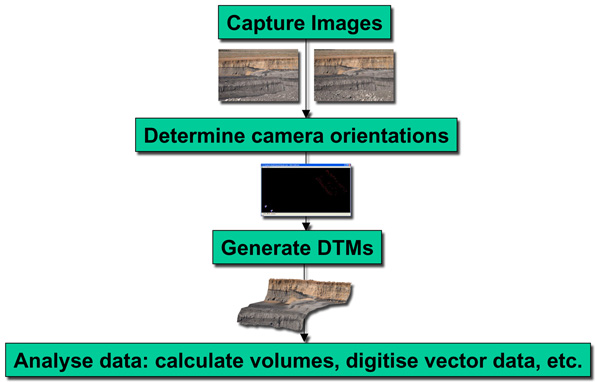
When using 3DM Analyst Mine Mapping Suite for aerial mapping, processing is normally performed completely within 3DM Analyst, although data can also be exported in DXF format as points (surface model), triangles (surface model), point strings (contours, cross-sections, and digitised vector data), and 3D Images if desired. Existing data can also be imported from other packages in the same formats for updating and/or comparison.
The software can generate contours as well as arbitrary cross-sections, and calculate volumes with respect to an arbitrary base or with respect to another DTM.
Orthophoto mosaics can also be generated with very little effort using the optional 3DM Ortho Mosaic software. 3DM Ortho Mosaic automatically performs colour correction and feathering between images to produce a seamless orthophoto and can also be used to generate TIFF + TFW files for use in 3rd-party software like Terramodel.
Case Study
Thiess Indonesia use 3DM Analyst Mine Mapping Suite for both terrestrial and aerial mapping of their coal mines in Indonesia.
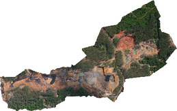
For one mapping project Thiess hired a Bell 206 helicopter for a day and flew two of their projects totalling 140 km in strike length from an altitude of 2500 ft, capturing approximately 1,200 images using a Canon EOS 300D equipped with a 28 mm lens, resulting in a pixel size of 20 cm on the ground. White bags filled with sand were scattered along the flight path to act as control.
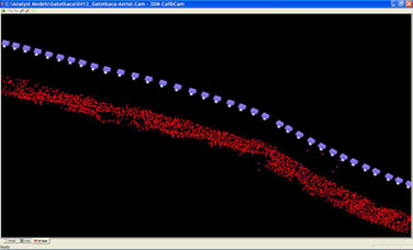
Loading all of the images for a site into 3DM CalibCam and asking it to automatically generate common points between the images takes about 20-30 seconds per image on a 2 GHz PC. Once complete, a handful of control points are digitised and a bundle adjustment performed. One of the sites, 6.5 km long, had 35 images captured in three minutes from the helicopter flying at 80 kts (Figure 2). Automatically generating nearly 2,000 relative-only points in 3DM CalibCam took 16 minutes and the bundle adjustment took just under 60 seconds.
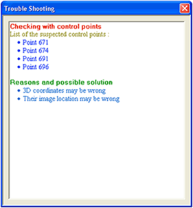
Because the control points were nearly circular in the images, not only was the software able to assist in digitising them by automatically centroiding them to precisely locate their centres when the user clicked in the vicinity, but after the bundle adjustment was complete the driveback feature could be used to predict the locations of the remaining control points and automatically digitise them as well. 29 control points were used originally, but 3DM CalibCam detected that four of them had surveying errors of up to 20 m so they were disabled (Figure 3). The height accuracy of the data based on the remaining 25 control points was about 0.2 m, in line with expectations.
Experimentally reducing the number of control points used to 10 resulted in an RMS change of control point heights of 0.08 m, indicating that the desired results could have been achieved with even fewer control points than were actually used.
Once the orientations were determined, automatically generating the surface model for the entire 6.5 km-long site using DTM Generator took less than 1.5 hours — completely unattended.